
Reestablishing the River and Our Connections to it
Home / Reestablishing the River and Our Connections to it / Reestablishing the River and Our Connections to it
Norway Lake Dam Removal and Pine River Restoration Project
DURING THE 20TH CENTURY, OUR WATERWAYS WERE IMPACTED BY THE construction of dams across the United States that were made to generate electricity for growing communities. Over the years, many dam structures that once served communities’ needs became obsolete as new and larger electricity generation infrastructures were built. After many decades of dams being in place, their static presence made for a dynamic situation of ecological failures. Dams cut off the waterways’ life source which resulted in habitat loss, build-up of pollution-rich sediments, dangerous conditions for people to be around, flood risks, and other unique issues depending on locations and the context of each structure. Today, many communities find themselves at the crosscurrents of two daunting realities: dealing with aging infrastructure that no longer performs its intended purpose and/or figuring out how to restore a broken and often polluted ecosystem. If only it was as easy as removing a dam and calling it a day. The logistics of decommissioning a dam, removing it, and restoring an ecosystem takes years of analysis, planning, designing, permitting, and construction that requires the coordination of professional engineers, landscape architects, scientists, agencies, and community leaders.
The Norway Lake Dam Removal and Pine River Restoration project in Pine River, Minnesota, led by Bolton & Menk, provides a case study example of what it takes to execute a complex project that not only removes an obsolete dam but also restores the natural flow of a river.
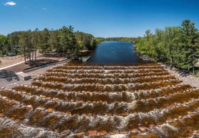
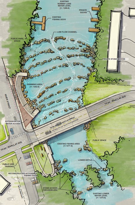
The Norway Lake Dam, constructed in 1910, stretched approximately 200 feet across and stood 13 feet tall, forming the southern end of Norway Lake, a 500-acre reservoir that rests along the Pine River. The dam outfall was utilized for creating electricity until 1946 when it was decommissioned. The Norway Lake Dam was also utilized by MnDOT with the construction of Trunk Highway (TH) 84 on the dam embankment along with a concrete bridge over the spillway. In 2014, the Minnesota Department of Natural Resources (MnDNR) Dam Safety staff analyzed hydraulics and unfortunately concurred the dam to be high-hazard and a significant fish barrier. The city wanted to improve public safety and access, reduce flood risk, and reestablish aquatic organism connectivity. To accomplish this, Bolton & Menk collaborated with the City of Pine River, the Minnesota Department of Transportation (MnDOT), and MnDNR in exploring multiple alternatives to remove the high hazard dam, relocate TH 84 off the dam, and install a rock riffle that provides the needed capacity, keeps upstream water levels, restores fish passage, improves safety, and provides recreational benefits to the community.
The multi-disciplinary team of landscape architects, water resource engineers, and civil engineers was instrumental in creating design solutions that would achieve the goals of the client (City of Pine River), MnDOT, MnDNR Dam Safety and Fisheries, and requirements from regulatory agencies. The design approach relied heavily on the cross collaboration of experts for establishing a vision of shared values and technical aptitude to create an implementable project that connects people to the river and enhances the ecology of the Pine River watershed without disrupting TH 84 connectivity.
ASSESSING THE OPTIONS
The Norway Lake Dam in Northern Minnesota had a high hazard classification since it did not have the spillway capacity to pass a 500-year flood without overtopping. If the dam were to fail during a 500-year flood, 45 homes and buildings were at risk of damage.
In 2013, Bolton & Menk began working with the City of Pine River on a feasibility study to assess options including dam removal, rehabilitation, and replacement. The 2014 Norway Lake Dam Feasibility Study report included preliminary roadway alignments by MnDOT, spillway alternative solutions by subconsultant AECOM, Norway Lake Dam Breach Analysis by MnDNR Ecological and Water Resources, and a Rock-Riffle Concept by MnDNR Fisheries.
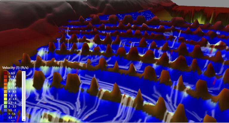
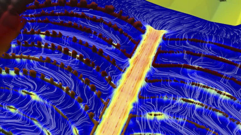
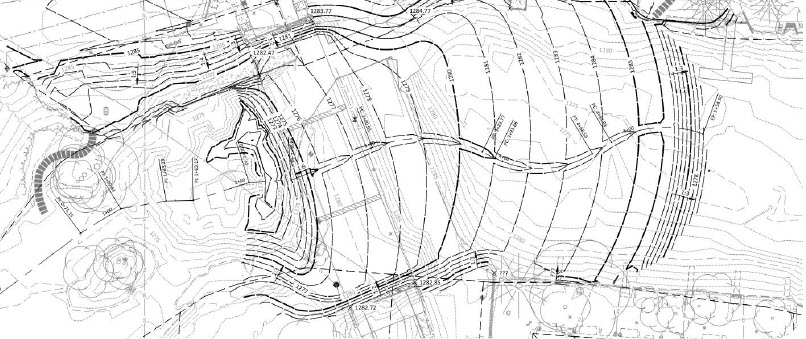
Through digital modeling, it was determined that a straight channel would result in water moving too quickly with too large of a drop for fish to be able to swim upstream. The grading and design of rock riffles and water flow had to be designed specific to aquatic species needs and maintain existing reservoir water levels. The rock riffle flow line creates an S-curve to get the right amount of drop within the horizontal distance between the Norway Lake recreational area above and Pine River natural area below.
With the information from the digital modeling and design incorporation of community wishes, the design team completed the Pine River Rock Riffle Preliminary Feasibility Report in 2017. This report included a preliminary layout of the rock-arch rapids, an estimate of hydraulic performance and upstream water levels, a description of proposed features, and the estimated construction costs. With the City of Pine River reviews and approval of the proposed rock riffle project, the feasibility report was presented to MnDOT and the MnDNR in February of 2018. The group agreed the City of Pine River would be a great candidate for grant funding and should submit a grant application to the Lessard-Sams Outdoor Heritage Council (LSOHC).
Working with the City of Pine River, Bolton & Menk continued to progress the rock riffle design and developed additional displays and graphics to help tell the story of the Norway Lake Dam Removal. This technical data paired with graphic illustrations helped the City of Pine River prepare and submit an LSOHC grant application to replace the Norway Lake Dam with a rock-arch rapids. Following the presentation at the LSOHC public hearings in September of 2018, the city was notified that $1 million (about 40% of the request) was being recommended. In December 2018, the LSOHC revised the grant allocations and awarded $2.3 million, the full amount requested, to the Norway Lake Dam Rock-Arch Rapids project.
“The Norway Lake Dam Removal and Pine River Restoration project in Pine River, Minnesota, led by Bolton & Menk, provides a case study example of what it takes to execute a complex project that not only removes an obsolete dam but also restores the natural flow of the river.”
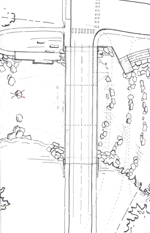
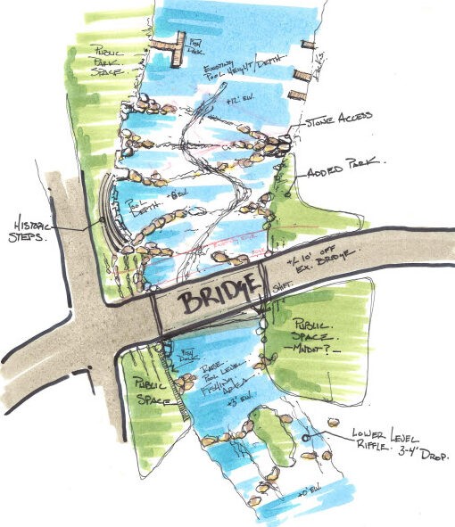
The landscape architectural drawings created for this project were helpful to convey project concepts to citizens and funding partners.
REESTABLISHING THE RIVER AND OUR CONNECTION TO IT
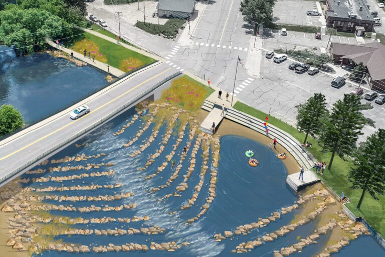
The primary goal of the project was to remove the dam and replace it with rock-arch riffles to improve public safety, reduce flood risk, and reestablish aquatic organism connectivity, while reconnecting meaningfully to the adjacent park, beach, and historic Workers Progress Administration (WPA) era structures. The existing dam structure was unsafe for people to be around and was armored with railings, fencing, and “KEEP OFF” signs—all signals this was not a place for people. The design team discussed the value of reestablishing the river as a place for the community to enjoy and a place to create a connected habitat for aquatic life.
To find the balance needed for both functional values, the team had to study in fine detail the realities of how the rock riffle would work. The team knew visitors would be drawn to the rocks and want to jump from rock to rock for fun or use them as a place to fish from, but what the team really needed to know was how the rock sizes and placements would benefit aquatic species. To test this, the team used digital modeling. The models determined that a straight channel would result in water moving too fast for the fish to be able to swim upstream. The straight channel also had too much vertical drop within the amount of horizontal run that was available. As a result, the landscape architect developed an S-curve channel that created more horizontal run and an undulating course that slowed the water velocity to a range that is ideal for fish passage. The S-curve’s shape meshed well with the curved shape of the existing (to remain) WPA era seat walls that define a portion of the western edge of the river.
The curve of the seat wall and the curve of the channel became an “aha! moment” in the design that led to the creation of a site plan based on a series of parallel curves that create the river edges and stepped rock riffles. The landscape architecture and engineering team collaborated on establishing a grading plan that united the series of curves from land to river. The next step in the design began to layer in the materials needed to ensure a healthy ecosystem and long-term resilience. The rock riffles would require boulders large enough to create the vertical height needed to transition from the Norway Lake level to the Pine River level and to create the specific range of drop between individual riffles. The boulders also proved to be large enough to create calm waters behind them for aquatic species to use for habitat and for a place to rest as fish dart from one spot to the next on their way up the stream. This is an important aspect as fish need to be able to move upriver and a continuous flow would prove too powerful for some species to be able to continuously swim against for a long duration. The boulder size became a feature for human use, as they are a perfect range of sizes for both kids and adults to explore the river—walking or jumping from one to the next, or sitting and enjoying nature on the larger rocks. As the boulders of the rock riffles meet the streambank, the stones transition down to fist-sized cobbles that maintain a shoreline edge that doesn’t erode away due to the constant flows of the river. The upper portions of the shoreline then transition to a gravel-sized aggregate that leads up to the existing WPA relic seat walls. This material allows for ease of walking around at the edge of the river.
Building off the concave curve of the seat walls, the team designed a series of pre-cast concrete retaining walls that create S-curve extensions. This series of walls create terraces that feather into the new bridge abutments to establish a consistent design language and flow through the site. The landscape architects specified native grasses and forbs that help slow and absorb water that sheet flows off the adjacent park lawn. The plant species have proved to be attractors for avian, terrestrial, and pollinator species and added an element of beautification that the community is proud of.
The project completed construction in 2022 and has proven to meet both the ecological goals and site functionality for the community to enjoy. The completed project has resulted in a river that is much safer to recreate in and around than previously when the dam, at-grade highway, and spillway infrastructure was inhospitable for people to be around.
In the end, this project reconnected 134 lakes and 80 miles of river in the Whitefish chain of lakes. The established ecological connectivity benefits fish, mussels, and many game and non-game animal species. It is a place that is well-loved by the community and is a favorite place to fish, swim, and recreate in the heart of the City of Pine River. It provides ADA access to the river’s edge for fishing and maintains historic WPA-era structures that are part of our country’s rich history in establishing public infrastructure for enjoyment.
“The completed project has resulted in a river that is much safer to recreate in and around than previously when the dam, at-grade highway, and spillway infrastructure was inhospitable for people to be around.
In the end, this project reconnected 134 lakes and 80 miles of river in the Whitefish chain of lakes.”


Britton Jones is a landscape architect whose work for the past 20 years aims to create social and ecological vibrancy. His work in reestablishing ecological function and human interaction with urban streams and wetlands has been a focus in his career. Britton’s experiences specifically include the removals of dams and hardened shorelines to restore Mill River (Stamford, CT), Bayou Auguste Phases I-IV (Biloxi, MS), and a current project on the Zumbro River (Rochester, MN). He has led the visioning for other projects that include Sarracenia Nature Park (Moss Point, MS), Resilient Bridgeport (Bridgeport, CT), Topeka Riverfront Vision Plan (Topeka, KS), and Rotten Bayou Watershed Implementation Plan (Hancock County, MS).