

Countless calls, emails, and concerns about the same construction project over and over can become mind numbing, and tedious, and repetitive, and monotonous, and… you get the picture. In our tech-savvy world, what if there was a way to increase efficiency by having all concerns and answers filter to one place for one project? What if the voices of the community could direct the outcome of the project before it even began?
INPUTiD™ is a comment mapping site that allows the public to comment, like/dislike, and respond to ideas pertaining to specific locations of a project relevant to their community. Through this GIS-based web application, community members can identify problem points and give input on design concepts before they come to fruition. Once the public shares their ideas and concerns, data is collected and analyzed so designs can be altered to meet the needs of their community.
How do community members use and benefit from INPUTiD™?
When a project is in its initial stage, an INPUTiD™ webpage is created and shared on a community’s website and made accessible to residents. The platform efficiently organizes data that can be easily analyzed by the project team. During the pandemic, INPUTiD™ flourished as a way to obtain location-specific community feedback since traditional open houses were at a halt. Clients and residents alike appreciated being able to engage on a project virtually.
Minnetonka Boulevard Reconstruction Project: Multi-use Trail vs. Sidewalks
Metro area design projects are great places to implement INPUTiD™ since highly trafficked areas see more use from a variety of multimodal users (bikes, cars, walking). The most commented project site of INPUTiD™ is the Minnetonka Boulevard Reconstruction Project in Hennepin County, Minnesota. The area between Highway 100 and France Avenue is a highly populated and traveled walking-focused community. With the previous roadway not meeting the community’s need, the project aimed to create areas for pedestrians and bicyclists to safely get around.
Maddie Peters, communication specialist for the reconstruction project, used INPUTiD™ to learn about areas of potential improvement. Anonymous comments were given on two different project concepts: one containing multi-use trails, and one with a sidewalk on one side and a bike trail on the other. Individuals made comments in different categories from likes, dislikes, concerns, ideas and opportunities, and other.
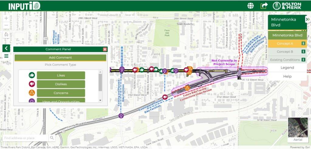
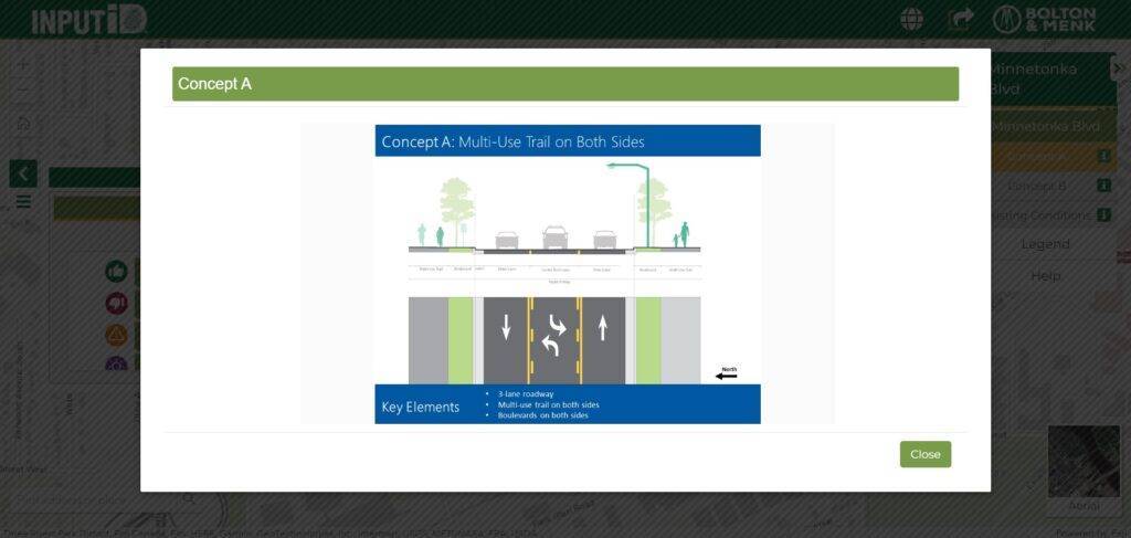
When different concepts are available, individuals can comment specifically on each concept. Concept overviews are detailed to provide the public with critical information to help them form an opinion on what may or may not work well for their community.
Once submitted, the project team receives the feedback and can begin analyzing the most popular topics and liked/disliked comments. Following analysis, the project team shares themes with the clients, then with the public either through an open house, city council meeting, email or website update.
“Younger generations have been really excited about this tool, since it provides a fun way to get engaged with community improvements,” said Maddie Peters. This user-friendly tool opens up feedback to a wider range of demographics due to increased accessibility.
Merle Hay Road Corridor Study: Imperative Opinions
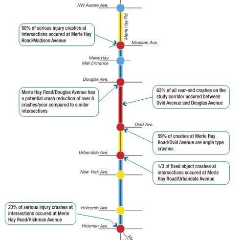
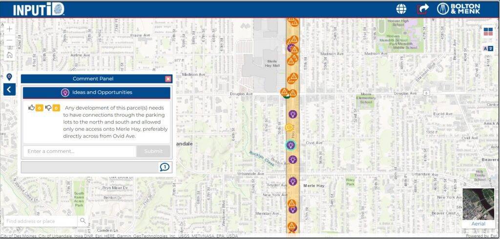
Located on the western edge of Des Moines, Iowa, the mile and a half study area lies within a major commercial corridor. Well before project concepts to improve the corridor are created, the interest and opinions of the neighborhood residents were imperative to the project’s future success. This vocal group of community members were introduced early in the project to allow the project team to gather information on what corridor issues were of utmost concern to stakeholders.
Like most projects using INPUTiD™, the existing project map was released on the web-platform, and users were able to comment on the project before concept creation begins. INPUTiD™ can be used in the beginning of a project for input on problems with existing conditions and near the end of design for refining potential solutions. In this project, Chris Albrecht, project manager, said “We want to find a way to balance functionality and aesthetics. Residents made it very clear through direct input and INPUTiD™ they felt a more aesthetically pleasing, welcoming corridor was a way to foster a better business environment for the greater Merle Hay area.”
Another supplementary customized GIS tool used was GeoCP™ 360. GeoCP™ 360 records an interactive photo of the corridor (think Google maps) to help communities review the current conditions of the roadway at a snapshot in time. Using this tool, community members can visually drive down the corridor, offering different angles than they see walking the streets every day.
Analysis and conceptual designs for Merle Hay are underway. Considerations for the corridor include expanding roadway capacity based on projected traffic volumes, identifying a quick transfer point for the DART transit line near the corridor, better pedestrian accommodations, and eliminating commercial access points to address crash history.
The Benefits of Anonymous Comments in INPUTiD™
The anonymity of INPUTiD™ allows individuals to be more truthful and candid in their answers, providing clearer insight into what changes people want to see. On the contrary, by presenting an idea in front of a group of people, you’re putting yourself in the line of fire for unwanted glances and rebuttals if your idea isn’t embraced. With an anonymous platform, everyone takes on the same identity and starts out on the same playing field.
“When 14 of the most passionate people show up to a public meeting, you may hear a strong opinion delivered by the most confident person in the room,” said Chris Albrecht. The strongest and loudest opinion may sometimes be the minority idea, so INPUTiD™ creates a safe space for individuals to give input. Since many community members cannot attend a two-hour open house, this opens the doors for more diverse opinions and more refined answers.
Wouldn’t that be dangerous if project team members pretend to be anonymous individuals? Individuals on the project team are required to identify themselves (i.e. Admin Comment) to make sure answers cannot be seen as deceitful by favoring the project they are working on. The project team can use the platform as an opportunity to answer and clarify common questions.
How was INPUTiD™ realized?
The inception of INPUTiD™ began in 2018, when a need arose for community input on transportation projects. John Shain, principal GIS project manager, mentioned, “Bolton & Menk project managers were searching for ways to facilitate innovative public engagement. Through collaborative efforts, our GIS group developed INPUTiD™ as a great tool and solution to help our clients.” The first uses of the program involved the community sharing their likes and dislikes on corridor study projects that pertained to their neighborhood. After the first transportation projects, the program took off and expanded for public uses in different sectors, including utility projects, park and trail planning, and land use planning. Line work features were also added to the program to show proposed roadway designs to the public. Design concept options were also uploaded so the public could visualize the different directions the project could take, while giving feedback along the way.
“We wanted to give people a voice on what future development should look like in their community” said David Sandberg, who was imperative to creating INPUTiD™. “This tool was developed to fill the gap between community ideas and the ones designing the project.” Users can expand on their comments and ideas by placing a location-based point and uploading attachments (i.e. photos, documents). Users and/or the project team can also reply to comments creating a two-way interaction. This web-based public engagement platform was born out of multiple collaborative efforts.
If projects are delivered without seeking community input, the solution may be missing the mark on residents’ concerns and desired changes. Instead of being on the outside looking in, it is best to go right to the source. Community members who walk and drive their streets every day are the real experts on their own communities. We simply provide them the tools they need to amplify their voice and help bring their vision to life.
Learn more about INPUTiD™ and other GIS engagement tools here.

John Shain began his career with the firm in 1999 after graduating with a degree in professional geography. His passion for local government and computer science morphed into an interest and expertise in mapping and displaying data. Bolton & Menk was willing to take a chance with John and embraced his ideas for GIS that were not yet widely practiced. Now, Bolton & Menk is a premier GIS provider for municipalities in the Upper Midwest. As the leader of the GIS work group, John has managed a variety of GIS projects that include municipal implementations of GIS systems, public utility and infrastructure mapping, stormwater management, and web application development.

As a GIS specialist, David Sandberg provides GIS support on various projects, including data collection, data management, spatial analysis, and map creation. He is especially experienced with designing and creating online interactive maps. David began his GIS career in 2016 and supports Bolton & Menk’s transportation, planning, and project communication work groups. He uses new technology and researches products and software to provide the best solutions for our work groups and clients. He excels at creating map figures, performing data analysis, and online interactive maps and applications. He is passionate about providing spatial analysis and tools to help make better decisions within the communities we serve.

Chris Albrecht is a senior transportation project manager who began his career in 1996. He serves as the transportation practice lead for the Iowa market. His experience as both a private-sector consultant and academic researcher includes transportation planning, traffic impact and major investment/corridor studies, traffic safety, ITS and advanced technologies, travel demand modeling, and GIS. This diverse experience makes him a great fit to meet the various needs of our clients. Chris is passionate about bringing a broad array of transportation solutions to communities throughout his home state.

Maddie Peters is a project communication specialist for Bolton & Menk who began her career in 2019. She enjoys working with communities of all sizes impacted by planning-related activities. Maddie provides expertise in multimedia communication, event planning and coordination, writing and editing, social media, and graphic design. Her skills thrive in environments of collaboration and relationship building.