
MnDOT Separated Bicycle Facility Design Guide
Home / MnDOT Separated Bicycle Facility Design Guide / MnDOT Separated Bicycle Facility Design Guide
In 2020, MnDOT adopted the Minnesota Bicycle Facility Design Manual to provide designers and planners with information to develop safe, consistent, and predictable bicycle facilities along MnDOT’s trunk highway system. However, MnDOT recognized that existing bikeway design documents —both state and federal—provide guidance on when bike facilities should be off-street and separated from motor vehicle traffic, but they do not clearly address when to build a shared-use path versus building a combination of separated bikeways and sidewalks. To help fill this void in bikeway design guidance, MnDOT set off to develop a guide that would assist practitioners in selecting the most appropriate bicycle facility based on land use context, pedestrian access density, and right-of-way. The guide was developed through an iterative process, with new questions emerging as initial questions were answered, resulting in a strong supplement to MnDOT’s 2020 manual.
The guide is organized into three sections:
- When to Separate Bicyclists and Pedestrians
- How to Separate Bicyclists and Pedestrians
- How to Design Bicycle Facilities at Intersections
Each section builds off the previous one, helping bikeway designers navigate the often challenging and murky decision-making process with separated bikeway and shared-use path design.
Section 1: When to Separate Bicyclists and Pedestrians
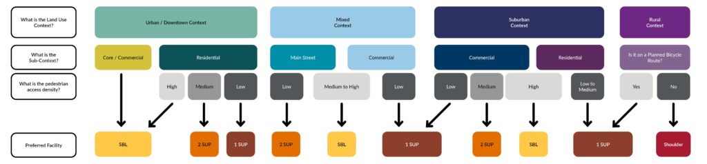
There is no industry standard that defines when pedestrians and bicyclists should be separated, but practitioners generally agree that separation is recommended when there are high volumes of either user group. Pedestrian counts are rare and can be difficult and costly to obtain, so this study developed a methodology to estimate pedestrian activity by using the number of building entrances along a corridor as a proxy for pedestrian counts. To help review and truth the methodology, the project team selected six state highway corridors across the state and counted doors on each ½‑mile segment.
After reviewing the counts, they were categorized into low, medium, and high pedestrian access levels based on the following thresholds:
- High: 60+ access points per ½ mile
- Medium: 40–59 access points per ½ mile
- Low: fewer than 40 access points per ½ mile
A corresponding flowchart was developed to guide practitioners to a recommended bike facility type. Separated bike lanes (SBLs) provide the greatest comfort by physically separating bicyclists from pedestrians. “2 SUP” indicates shared-use paths on both sides of the road; “1 SUP” provides a shared-use path on one side and a sidewalk on the other. Designers still retain flexibility to choose separated bicycle facilities even when a shared-use path is recommended.
In rural areas, MnDOT’s decision making process is simpler, and the bike facility choice is between paved shoulders and a shared-use path. The key factor is whether a corridor is part of a planned bicycle route. Corridors with planned bicycle routes should consider a shared-use path, while other rural corridors should use widened shoulders—with Federal Highway Administration guidance recommending 6 ft shoulders on low-volume roads and 10 ft shoulders on high‑volume roads.
Section 2: How to Separate Bicyclists and Pedestrians
Once the decision has been made to separate bicyclists and pedestrians (Section 1), there are still many design decisions to be made about how to separate users, which is outlined in section 2 of the guide. This phase of work was heavily influenced by stakeholder workshops that were conducted with blind/low-vision pedestrians, people who use mobility devices, and people who are frequent bicycle users. Each group was taken on a tour of various streets in Minneapolis and the surrounding region that have a variety of bicycle facility types. The groups were asked questions about how they felt while on each facility, if they knew what certain roadway markings or treatments meant, and their general experiences walking and rolling in these areas. The lessons learned from these workshops heavily informed the design guidance for how bicyclists and pedestrians should be separated. As one mobility device user pointed out, “If the facility is safe and accessible for us, then it will be safe and accessible for everyone.”
Following the workshops, the project team developed recommended behind-the-curb dimensions for each of the following facilities:
- Separated one-way bike lanes
- Separated two-way bike lanes
- Shared-use paths
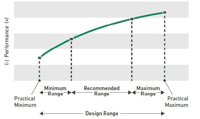
The dimensions for each facility were categorized into four design ranges based on the AASHTO Guide for the Development of Bicycle Facilities Fifth Edition: Maximum Range (the most width provided), Recommended Range, Minimum Range, and Practical Minimum (the least width provided). In some corridors, the available width may be too narrow to construct separated facilities, so the guide recommends considering shared-use paths in those instances.
Section 3: How to Design Facilities at the Intersections
Designing intersections is often the most challenging part of a bikeway project, and another area with limited design guidance. This is where many elements compete for space, such as ADA curb ramps and landing areas, intersecting sidewalks, signal poles, push buttons, signs, building access points, landscaping, and street furniture. To address the void in design guidance, the project team developed exhibits that include intersections with corner islands, pedestrian and bicycle mixing zones, and street-level bike facilities with pedestrian and bike infrastructure on both the main roadway and the side street. The exhibits went through numerous rounds of review and edits from staff from various MnDOT departments, with a close eye on ADA compliance, winter maintenance considerations, pedestrian and bicycle user experience, and constructability.

MnDOT’s leadership was essential to the successful development of the decision-making guide and its accompanying design exhibits. Working in partnership with Bolton & Menk, MnDOT guided the creation of the supplemental document and facilitated stakeholder workshops with a variety of user groups. Planning and design staff from multiple Bolton & Menk locations contributed their nationwide bikeway design expertise throughout the process. The team was proud to support MnDOT in producing a guide that will shape bicycle and pedestrian facilities across Minnesota for years to come.
Want to learn more about why safe, accessible communities matter? Learn more about building inclusive communities through safe bike access, here.

Zoe Huebner is a transportation planner at Bolton & Menk where she focuses on creating safe, accessible, and sustainable transportation systems. Since starting her career in 2023, she has contributed to various projects including project planning, document design, community engagement, and grant writing, with experience supporting RAISE/BUILD and SS4A grants. Outside of work, she is an outdoor enthusiast who values the connection between mobility, community, and quality of life.

Connor Cox is an active transportation and transit practice leader at Bolton & Menk, guiding active transportation planning work across the Midwest. Since starting his career in 2012, he has led numerous pedestrian, bicycle, and Complete Streets projects at municipal, regional, and statewide levels, with an emphasis on safety, accessibility, and connectivity.

Cody Christianson is an active transportation and transit practice leader with a background in transportation engineering that began in 2008. He brings national expertise in bicycle and pedestrian infrastructure, designing safer and more inclusive multimodal systems through community-driven, context-sensitive solutions.