
Planning Your Future with GIS Mapping
Home / Planning Your Future with GIS Mapping / Planning Your Future with GIS Mapping
Many know Geographic Information Systems (GIS) as a mapping tool. While GIS mapping is still used daily at Bolton & Menk, this tool is becoming increasingly critical for communities to address the challenges they will face in their future, including infrastructure management, resiliency, and supporting their sustainable future.
GIS Mapping for Urban Planning
GIS supports urban planning by providing insights into land use patterns, population density, and transportation networks. This helps planners make informed decisions about zoning, development, and infrastructure projects, ensuring growth is sustainable and beneficial to the community.
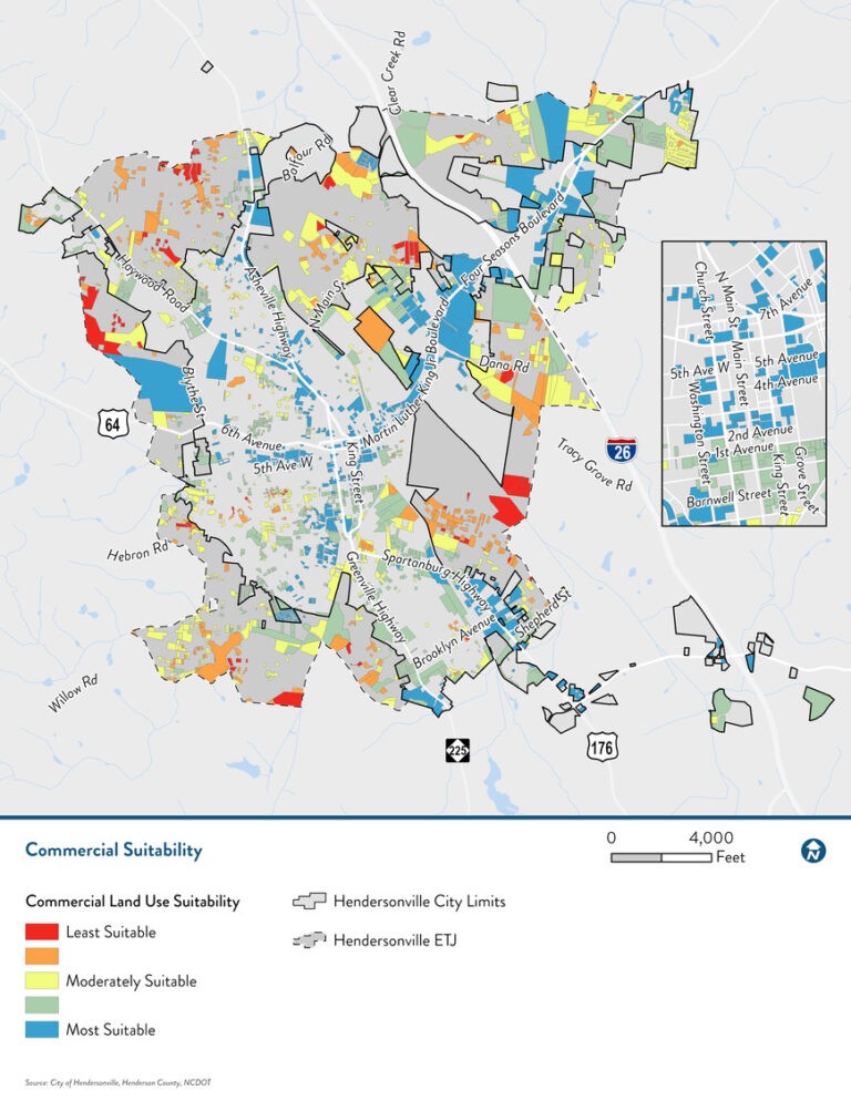
Using GIS mapping to plan future land use provides objective and defensible measures to identify locations best suited for residential, industrial, or commercial growth, as well as protecting open spaces that enhance quality of life and protect our natural resources.
The location of development has posed a challenge for communities for decades. As part of the Hendersonville, NC Gen H Comprehensive Plan, GIS Specialist Brita Dawson used custom Python tools to evaluate various factors, including proximity to schools and historical landmarks, current land use, zoning, access to water and sewer utilities, roadway access, steep slopes, and floodplains, to determine areas best suited for development. This evaluation identified alternative growth scenarios, allowing flexibility for decision makers in Hendersonville to accommodate changes in commercial or housing demand in their community.
Preserving Neighborhood Character in Charlotte, North Carolina
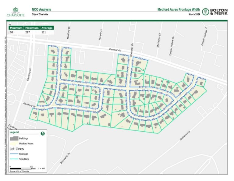
In some neighborhoods of Charlotte, new development or infill may be unwelcome by the current residents due to the new construction’s lack of following the neighborhood’s existing character. Picture quaint, woodsy, single-family suburbs with lots that are suddenly being cleared for the looming modern architecture of a multifamily residence. Design parameters are set to protect character through adoption of a Neighborhood Character Overlay District (NCOD). However, quantifying the “feel” of a neighborhood requires significant spatial analysis.
The City of Charlotte developed a new process for eligible neighborhoods to preserve their character. Bolton & Menk analyzed the existing conditions and provided average design standards for the various eligible neighborhoods looking to advance in the NCOD process. These categories included lot frontage widths, total building coverage per lot, the setback distance of the houses from the lot frontages, primary and accessory building heights, the amount of available parking area per lot, and the number of trees in the road right of way.
The City of Charlotte anticipates additional neighborhoods to apply for this NCOD designation, so it was critical for the GIS team to develop methodologies that were automated and repeatable.
Spatial analysis, led by Senior GIS Specialist Dr. Madeleine Bolick, PhD, developed unique methodologies for each of the six design categories using the programming language Python, making it easy to repeat the analysis for future neighborhoods. GIS mapping played a crucial role in analyzing existing conditions and providing average design standards for eligible neighborhoods. This collaborative effort helped establish design guidelines that protect neighborhoods from unwanted development, ensuring the community’s character is preserved for future generations.
Enhancing Stormwater Management with GIS Mapping in Horry County, South Carolina
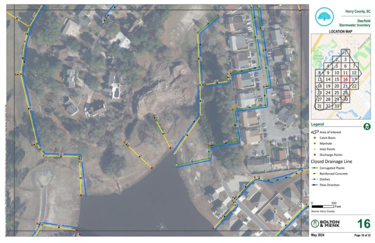
Another key issue communities face is addressing issues with existing infrastructure. GIS has long been the preferred tool for communities to identify and track assets. However, historically stormwater was a forgotten utility. Communities like Horry County, South Carolina have experienced significant growth over the past 50 years, leading to stormwater management challenges in communities like Island Green, Bucksport, and Deerfield.
A comprehensive survey of all stormwater structures, pipes, and ditch conveyances was conducted to address these issues. Bolton & Menk’s team, including GIS Technician Daisy Ryan, transferred this data into a GIS system, attributing all relevant information including invert elevations, materials, and diameters.
The GIS data allowed water resources engineers to map watershed flow patterns, providing a clear understanding of regional connectivity and localized flooding impacts. This detailed inventory laid the foundation for future improvements, ensuring stormwater systems are effectively managed to prevent flooding and protect community infrastructure.
GIS Tools for Innovative and Accessible Community Engagement
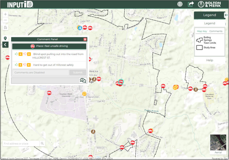
GIS mapping tools can be used to engage the community in planning and decision-making processes. Interactive maps and data visualizations help residents understand local issues and provide input on projects that affect their neighborhoods.
Our GIS team developed a tool that takes equitable community engagement to the next level. INPUTiD™ helps our clients better engage with stakeholders and provide a more complete picture for the community. This enables residents to use a fun and easy web-based tool to share information via our clients’ websites and social media outlets. This communication tool helps improve a community’s ability to reach a broader audience, while providing a place for residents to interact with each other and/or staff.
GIS mapping helps us unlock data that is crucial to helping communities thrive. When we harness the data available to us through innovative GIS problem-solving, our clients can serve their communities in a way that significantly enhances quality of life for the present and future.
 Jim is a GIS project manager in Raleigh, NC. He began his career in 2011 and has served in a variety of project roles, including project management, GIS project development, UAV services, municipal asset inventories, multimodal transportation planning, and public engagement. He believes that the power of technology can help create more sustainable communities. A problem-solver at heart, Jim is passionate about providing creative solutions using a broad array of technological resources.