

In January 2021, the U.S. Environmental Protection Agency (EPA) released the update to the Lead and Copper Rule of 1991, the Lead and Copper Rule Revisions (LCRR). This rule focused on finding sources of lead in the public water supply and removing these sources from distribution systems. The first item systems need to complete to meet the new LCRR requirements is the service line inventory.
A service line inventory is a record of every service line in a system’s distribution network, along with the line material and location. The entire service line needs to be included in the inventory, including any portions which are privately owned. There are four categories each line must be classified as: Lead, Non-lead, Galvanized Requiring Replacement, and Unknown.
Lead service lines are, as the title implies, lead. Non-lead lines are any service line material that is not one of the other three categories. This includes PVC, copper, brass, or other material. ‘Galvanized Requiring Replacement’ is a more complicated classification; if a galvanized line was ever downstream of a lead line or lead connector, it is ‘Galvanized Requiring Replacement’. This is because galvanized lines can attract lead in the water passing through it. When the water does not contain lead, the line can then leach the lead back into the water. They therefore become a “pseudo source” of lead to a water source and can cause elevated lead sample results even though there are no longer lead service lines or connectors. It should be assumed that all galvanized lines will require replacement unless it can be proven that the line has never been downstream of lead plumbing. For example, if a galvanized line was installed in 2005, well after the ban on lead service lines and connectors, it will not require replacement. This proof will need to be shown to the system’s primacy agency to be considered acceptable.
The unknown category should be used for any service line for which the material cannot be determined. Each system will be required to check the following records for service line material information, as well as any records the state deems necessary:
- Previous Material Evaluations
- Construction and Plumbing Codes/Records
- Water System Records (maps, drawings, meter installations, CIPS, SOPs)
- Distribution System Inspections and Records
Systems are not required to visually inspect the service lines. However, having service lines of unknown materials will make compliance with other portions of the LCRR difficult. Any unknown service line has to be treated as lead, meaning it will have to be included in a replacement plan and a sampling plan as lead. Any homes served by unknown lines will also have to be individually notified of their status.
Each service line needs a “location identifier”. This is some sort of designation which allows a reader to locate the specific service line in question. Some systems may have concerns about publishing a specific address for each service line due to privacy. The LCRR allows for this by using a different location identifier. Other options include streets, blocks, landmarks, intersections, or other locational descriptions unique to that service line. Systems can keep an internal record of service line addresses for ease of locating each line, but only publish the location identifiers publicly and in state submissions.
Planning, performing, and tracking a lead service line inventory can be overwhelming. There is a lot of information to gather and keep organized. Fortunately, there is an easy to deploy and use GIS-based solution that will simplify this task and provide a framework for effectively creating, executing, and monitoring a lead service line inventory.
The Lead Service Line Inventory Solution requires minimal investment in time and resources up front. Existing GIS data is not needed to begin, nor is any labor-intensive data collection. The inventory process can be started using readily available GIS data such as parcel information or geolocated water meters. By using GIS, the location identifier requirement for each service line can be more easily satisfied than using other location forms.
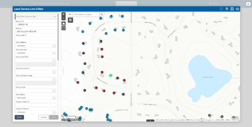
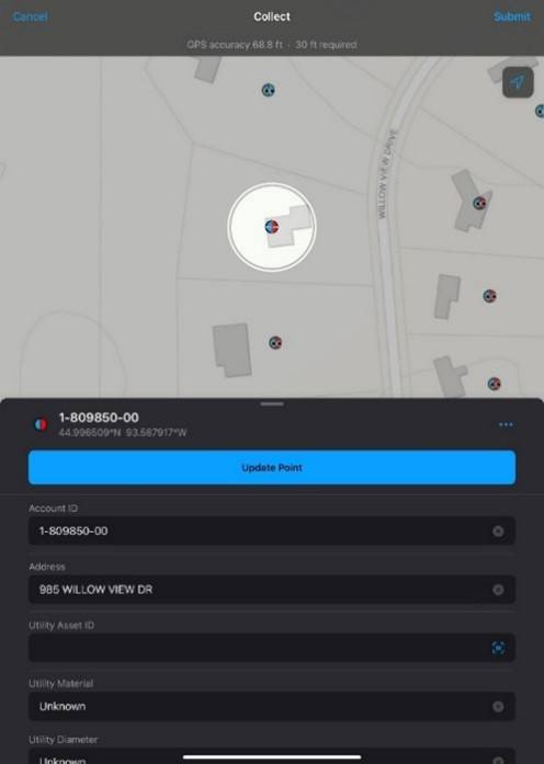
Once the solution is deployed, tracking all the readily available records can begin. Service line information can be batch edited to make the process quick and easy. For any lines that remain unknown, phone and tablet based mobile apps make documenting any needed inspections effortless. Photos can also be attached as proof of inspection.
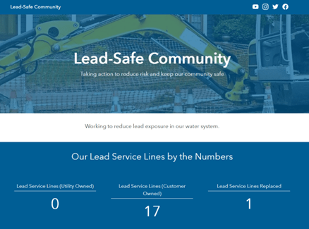
This recorded data flows into several automated dashboards and websites that can track inventory progress. These can be used internally or published for view by the public.
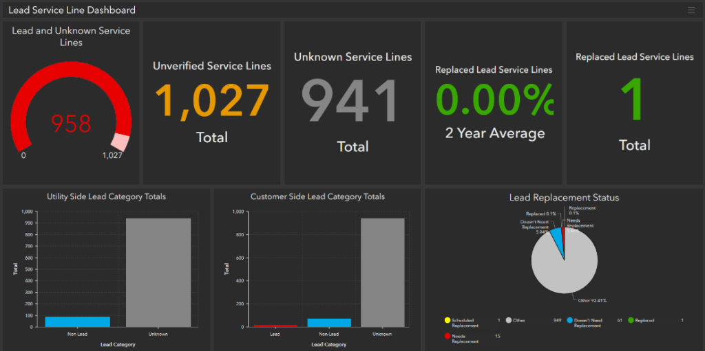
Once the inventory is complete, data can be continually updated as new information becomes available. This information can also be used to help plan and track the replacement process. Since the data exists in a tabular, GIS-based format, it can easily be exported to Microsoft Excel, or any other format required to satisfy regulatory requirements.
Completing an inventory of all service lines in a distribution system can seem daunting, especially if such an effort has not been done before. However, by tackling each requirement step by step, and using tools available for assistance, compliance can be achieved even for systems with limited resources.
Click here to learn about other water and wastewater solutions!
As published on the APWA-MN website.
 An environmental design engineer at Bolton & Menk, Meghan began her professional career in 2020. Her expertise includes water and wastewater treatment, water chemistry, environmental regulations, and large-scale data analysis. Meghan is passionate about problem solving and protecting the environment. In her free time, she enjoys watching movies and playing with her pup!
 Dave began his GIS career in 2015. He provides GIS services to internal and external clients and assists in creating and maintaining databases, map development, and asset management. He also creates, develops, and maintains various web mapping applications and handles project set-up, data collection, and data processing for high-accuracy GPS collection projects. Dave loves being able to provide a high-quality solution. Whether it’s a great looking map, clear and concise data, or just an answer to a question, he loves taking the time to do it right. Dave has extensive experience working with Esri GIS software and is experienced with AutoCAD Civil 3D, Microstation, and other design software.